Industrial Tree Plantations Linked to Higher Megafire Risk — New Science Raises Hard Questions for Managers
For decades, governments and companies have planted fast-growing trees — eucalyptus, pines, and other species — to meet global demand for timber, pulp, and wood products. These plantations have also provided jobs and income in many rural areas. But a growing body of research now shows that some forms of plantation forestry create the kind of fuel and forest structure that contribute to very large, high-severity wildfires — so-called “megafires.” This does not mean plantations are the sole cause of recent blazes, but it does change how we must think about landscape planning, company practices, and public policy. Various studies suggest that plantations in temperate regions are more likely to suffer stand-replacing wildfires than natural production forests — and that finding is forcing forest managers to reconsider long-standing practices.

In This Article
- What the New Science Shows
- Real People, Real Losses: Portugal and Chile
- What Managers, Companies, and Governments Should Do — Practical, Evidence-Backed Steps
What the New Science Shows
Two pieces of recent research crystallise the concern. A global analysis published in Nature Communications found that, after controlling for weather, topography and nearby human activity, plantations in temperate countries burned at higher rates than natural production forests — roughly twice as likely to suffer stand-replacing wildfire under the same conditions. The study also reports that between 2015 and 2022, some 17.1 million hectares of timber-producing forest were lost to stand-replacing fire, split between natural production forests (about 15.7 Mha) and plantations (about 1.4 Mha). This pattern held most strongly in temperate countries such as Portugal, Spain and parts of China and Russia.
At a finer scale, a lidar-based study of private and public forests in California’s Sierra Nevada — led by researchers at the University of Utah and colleagues — compared three-dimensional forest structure across ownership types and then measured fire severity after a string of recent large fires. The team found that privately managed, plantation-style stands tended to have dense, uniform tree stocking and continuous vertical fuels that let flames climb into the canopy; in extreme weather, those structural patterns strongly predicted high-severity fire. Jacob Levine, the study’s lead author, told reporters that the message is both stark and hopeful: stem density (trees per acre) became the strongest predictor of fire severity during extreme weather, and thinning to reduce density could materially lower future risk. According to the University of Utah press release, industrial forests had nearly one-and-a-half times the odds of high-severity burning compared with many public forests — a management signal that can be acted upon.
These scientific results sit alongside broader, climate-driven trends. The Food and Agriculture Organisation’s State of the World’s Forests 2024 and recent Global Forest Watch analysis document that wildfire frequency and intensity have increased in many regions as warming and drying trends intensify — meaning landscapes once resilient to fire are becoming more vulnerable. A report by FAO in 2024 warned that climate change is making forests more susceptible to wildfires and pests, compounding the management challenges for all kinds of forests, plantations and natural alike. Meanwhile, Global Forest Watch analysis reported that fires drove record tropical primary forest loss in 2024, underlining that the growing fire problem is global and multifaceted. Together, climate and land-use pressures are expanding the scale and severity of wildfires.
Below is a short statistics snapshot drawn from these studies and reports to help put the scale in plain numbers.
| Key figure | What it means |
|---|---|
| ~17.1 million ha (2015–2022) | Stand-replacing wildfire losses in timber-producing forests globally. (Natural production forest ≈ 15.7 Mha; plantations ≈ 1.4 Mha). |
| +100% | Average increase in burn probability for temperate plantations vs natural production forests under matched conditions. |
| ~1.5× | Odds of high-severity burning on industrial private land vs many public lands in the Sierra Nevada lidar study. |
| 2024 spike | Fires became the largest driver of tropical primary forest loss in 2024, reversing recent improvements — a reminder that fire risk is growing in many regions. |
Real People, Real Losses: Portugal and Chile
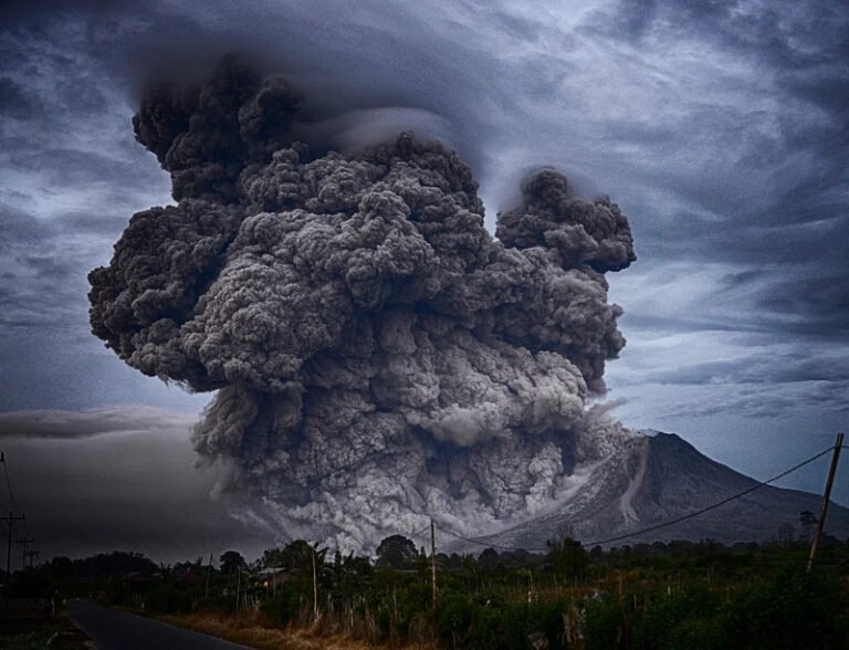
The science becomes urgent when you meet the people who lived through these fires. In Portugal, the June 2017 Pedrógão Grande inferno — which killed 66 people and burned tens of thousands of hectares — forced a national reckoning about how dense eucalyptus and pine stands had been laid across the landscape. Survivors and local business owners described a scene they compared to war; one café owner told Reuters that the destruction left the town “like a war zone.” According to Reuters, those eucalyptus stands were an unmistakable part of the landscape where the fire ran so fast and hot that escape routes became deadly.
In Chile, the human toll has been no less dramatic. The 2017 central-southern megafires — and repeated later seasons — razed communities such as Santa Olga and left residents furious and bewildered. People who lost homes and livelihoods described blackened streets and entire neighbourhoods gone; one local mayor described the scene as “literally like Dante’s Inferno.” Biologists and community leaders pointed to dense plantations of eucalyptus and exotic pines, planted decades earlier, as factors that allowed flames to move rapidly from the countryside toward towns. According to The Guardian, residents and scientists argued that plantations placed close to settlements and lacking adequate firebreaks amplified the danger.
These are documented accounts from journalists, local officials and researchers who responded to real disasters. They illustrate how the physical form of a forest — age classes, species, and spacing — manifests in human suffering when drought, heat, and erratic winds coincide.
What Managers, Companies, and Governments Should Do — Practical, Evidence-Backed Steps
The scientific work is unusually actionable: it points to forest structure and management decisions — things we can change — as major levers. That is the hopeful part of these otherwise worrying findings. Based on the best available science and experience from wildfire-prone landscapes, here are concrete steps that land managers and policymakers should consider.
First, prioritise landscape diversity and planning. Replacing large swathes of single-species, single-age plantations with a mosaic that includes mixed species, riparian buffers, and wider spacing reduces continuity of fuels and makes crown-fire spread less likely. The global analysis published in Nature Communications found that plantation homogeneity is one of the mechanisms that increases burn probability in temperate regions. Improving plantation diversity and landscape planning is, therefore, critical to reducing risk.
Second, scale up targeted thinning and mechanical fuel reduction where science indicates high stem density is driving risk. The Sierra Nevada lidar study concluded that reducing stem density — removing small trees, ladder fuels and excessive cohorts — materially lowers the chance of canopy-killing fires during extreme weather. Jacob Levine emphasised that density matters most in extreme conditions and that strategic thinning is an effective countermeasure. Thinning both small and mature trees in targeted ways makes forests more resilient.
Third, invest in and restore traditional and prescribed fire where ecologically appropriate. Indigenous and local cultural burning regimes historically reduced surface fuels and created patchy landscapes that are less prone to sustained, high-severity crown fire. Restoring controlled, well-managed burns — combined with mechanical treatments in higher-value plantation parcels — can reintroduce a safer fire regime, reduce accumulated fuels and protect communities.
Fourth, require better risk mapping, transparency, and regulation where plantations border towns. In Chile and Portugal, critics have noted that plantations often extend right up to settlement boundaries without adequate firebreaks or water infrastructure. Municipal planning rules that mandate buffer zones, defensible space, and verified fire-prevention measures can save lives. As The Guardian and other outlets have reported, communities have repeatedly raised concerns about plantations located close to homes. Legal and policy reforms should address these proximity risks. In both Chile and Portugal, the closeness of plantations to settlements has contributed to rapid fire spread and community losses.
Fifth, industry incentives must be aligned with public safety. Current commercial models reward rapid rotations and maximum yield, but policy tools — from adjusted subsidies and insurance conditions to new certification standards — can encourage companies to manage for long-term landscape resilience as well as short-term output. Researchers warn that plantation design choices involve a trade-off between productivity and resilience; policies should help shift that balance toward community safety and carbon security. Preventing wildfires in plantation systems is essential not only to protect timber supply but also to safeguard broader ecosystem services.